B. The Air Campaign Against Al Muthanna
Air attacks against Al Muthanna began on the first day of the air campaign, January 17, 1991, and continued through February 23, 1991 (Tab F). The United States launched at least 31 Tomahawk Land Attack Missiles (TLAMs) and flew 79 A-6 and F-117 sorties against Al Muthanna. The TLAMs attacked the more vulnerable buildings and other infrastructure targets, while the A-6s and F-117s attacked with precision-guided bombs the hardened storage bunkers and other facilities.
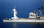
Beginning in the early morning of January 17, 1991, US Navy ships launched TLAMs (Figure 5) against chemical and missile targets for four days, but TLAMs are not effective against hard targets such as the Al Muthanna bunkers.[33] Launched from either a submarine or surface ship, the TLAM is a long-range, subsonic land attack cruise missile.
Figure 5. Tomahawk Land Attack Missile launches against a target in Iraq
Two flights of United States Navy A-6 Intruder aircraft attacked Al Muthanna on January 19, 1991, with GBU-10 and Mk-84 bombs (Tab F).[34] The GBU-10 is a laser-guided, 2000-pound bomb the pilot can guide to the target after release.[35] The Mk-84 is a 2,000-pound free-fall non-guided bomb.[36] The Intruder is a US Navy carrier-launched, ground-attack aircraft (Figure 6).[37]
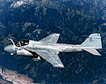
Figure 6. US Navy A-6 Intruder
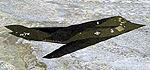
Beginning February 4, 1991, and continuing for 20 days, USAF F-117s (Figure 7) attacked Al Muthanna with GBU-10 and GBU-27 bombs (Tab F).[38] The GBU-27 is a 2,000-pound laser-guided bomb with a warhead capable of penetrating hardened structures like Al Muthanna’s Bunker 2.[39] The F-117 Nighthawk is the first operational aircraft using stealth technology.[40]
2. Strikes Against Al Muthanna
According to US Central Command Air Tasking Orders, the US Navy launched 19 TLAMs against Al Muthanna targets on January 17, 1991, and 12 more on January 19 and 20. Three US Navy A-6 aircraft dropped 12 GBU-10 bombs and 3 additional A-6s dropped 12 Mk-84 bombs on January 19th (Tab F). Three more A-6s delivered Mk-84 bombs on January 27, 1991. These attacks proved relatively ineffective against the reinforced cruciform bunkers.[41]
On February 4, 1991, F-117s dropped 1 GBU-27 and 5 GBU-10 bombs on suspected chemical ammunition storage bunkers. The F-117s returned and dropped 55 more GBUs on suspected chemical warfare agent bunkers between February 7 and 8. Finally, on February 23, 1991, F-117s dropped 10 GBU-27 bombs on the Al Muthanna bunkers (Tab F). Aircraft video which F-117 pilots routinely used to preserve the history of their attacks against targets in Iraq confirmed these events.
The Combat Mission Report for US Air Force mission 3323B (Tab F) reports it destroyed Bunker 7 at Al Muthanna on February 8, 1991.[42] However, our careful review of the gun camera film from this mission revealed it actually attacked Bunker 2.[43] Since the mission flew at night in a hostile environment, it was easy for the pilot to mistake which bunker he struck.
We used the Weapons Effects and Performance Data Archival (WEAPDA) system developed by the Defense Special Weapons Agency to review the weapon effects, mission, and target data collected and assembled for most of the successful F-117 attacks on Al Muthanna. WEAPDA video shows that an F-117 attacked Bunker 2 with a GBU-10 on February 8, 1991. It shows the GBU-10 flying into a crater from a previous bomb strike. The video of this attack captured the expulsion of smoke and dust from Bunker 2.[44] Additional frames show several previous hits on Bunker 2, later confirmed on site by UNSCOM inspectors.[45] However, these other attacks did not penetrate the structure.
The Department of Defense defines bomb damage assessment (BDA) as "the determination of the effect of all air attacks on targets (e.g., bombs, rockets, or strafing)."[46] The BDA reports on Al Muthanna are physical, functional intelligence assessments of the installation’s operational capability.
Iraq stored filled chemical ammunition at Al Muthanna in the bunker storage area located at the north end of the Al Muthanna State Establishment main facility (Figure 3.) Iraq stored these weapons in partially buried bunkers constructed of reinforced concrete protected by several overlapping layers of sand, concrete, and earth.
During the war, BDA for Al Muthanna indicated the destruction of one bunker and superficial damage to the remaining seven.[47] The bunker reportedly destroyed, number 4 in Figure 8, suffered catastrophic destruction, probably because it held a large quantity of conventional high explosive munitions.[48] UNSCOM estimated that Bunker 4 held between 200,000 and 400,000 pounds of bulk high explosives.[49]
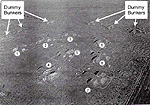
Figure 8. Aerial view of bunker storage area at Al Muthanna
US post-war intelligence estimated only four of the eight cruciform bunkers at Al Muthanna survived the air attacks without internal damage. Post-war on-site inspection revealed Bunker 2 was unusable. It had burned, and was filled with charred rocket bodies. No traces of chemical warfare agent residue were in or around Bunker 2, but a low-level vapor hazard, probably emanating from damaged and leaking 122mm rockets stored in the open, existed around some outbuildings.[50] UN inspectors verified that, of the eight cruciform bunkers at Al Muthanna, only one, later identified as Bunker 2, contained rockets with chemical warheads.[51]
4. UNSCOM Information on Bunker 2
UNSCOM inspectors conducted their first chemical inspection of Al Muthanna during early June 1991. The UNSCOM inspectors found evidence of repeated air attacks during the hostilities, and the site was very dangerous because of damaged chemical ammunition and unexploded ordnance.[52]
Iraq declared that Coalition bombing at Al Muthanna destroyed 2,500 chemical rockets containing sarin stored in Bunker 2. UNSCOM inspectors, however, were unable to verify the exact number because of the damage to the rockets.[53]
Using UNSCOM's estimate that Bunker 2 contained no more than 1,500 rockets filled with chemical warfare agent when destroyed, CIA estimates the agent in the rockets stored in Al Muthanna Bunker 2 had deteriorated to approximately 18 percent purity by the February 8, 1991, air strike, leaving about 1600 kilograms (1.6 metric tons) of viable agent.[54] CIA conducted modeling supporting this narrative as part of its reexamination of the potential release at Al Muthanna. This reexamination projected that a maximum of only 10 kilograms of sarin escaped from Bunker 2 during the first few seconds after the detonation. After that time, extreme temperatures caused by the bomb detonation and subsequent fire within the bunker, confirmed by Iraq, destroyed all remaining viable agent before it vented into the atmosphere.
Figure 9 is an aerial photograph taken after the war of Bunker 2 at Al Muthanna. The hole in the top of the bunker at the center of the cross is the destructive penetration caused by the air attack on February 8, 1991. The size of the bunker is indicated by the fact that the bomb hole is six meters (19.5 feet) in diameter.[55] The main entrance to Bunker 2 is at the opposite end from where the photograph was taken. Iraq stored munitions in the bunker transept extending left and right in the photograph.
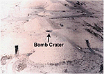
Figure 9. Al Muthanna cruciform chemical ammunition storage Bunker Number 2
Ground photography clearly shows damage to the bunker. Figure 10 shows the hole in the bunker’s roof as seen by a person standing on top of the bunker. This hole penetrates through the seven-meter thick roof.[56] Figure 10 does not show any debris of munitions outside the hole.
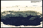
Figure 10. Hole in Bunker 2, Al Muthanna
Figure 11 is a close-up photograph looking through the hole into the interior of Bunker 2. It shows the steel reinforcing rods hanging from the concrete roof into the bunker and rocket remains among the rubble caused by the detonation of the bomb dropped by the US Air Force that penetrated the roof of Bunker 2. It shows most of the debris is inside the bunker and all the steel reinforcing rods are bent down from the heat and force of the detonation.
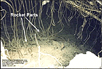
Figure 11. View into the hole in Bunker 2
Figure 12 is a photograph taken through the Bunker 2 entrance with the bunker number at the top of the photograph. It shows the soot stained walls and ceiling, and melted plastic hanging from the fluorescent light fixtures.[57] Thermoplastics begin to melt at temperatures above 100� Celsius (212 degrees Fahrenheit).[58] Since the heat near the entrance to the bunker must have exceeded that temperature for some period of time, the internal temperature of the bunker where the weapons were stored must have exceeded 150� Celsius, the decomposition temperature of sarin.[59]
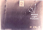
Figure 12. View into Bunker 2 through the main door
The photographs indicate the attack on Bunker 2 at Al Muthanna caused an intense fire within the structure, probably fed by burning rocket fuel and packing materials. They also show that debris from the bunker’s roof buried many of the rockets. This evidence supports the CIA estimate that most of the chemical warfare agent stored in the bunker either decomposed in the fire’s intense heat, or was buried in the debris from the bunker’s roof.
C. Analyzing the Health Risks from the Al Muthanna Attacks
Determining how the air campaign against Al Muthanna may have affected US forces required relying heavily on modeling and simulation to simulate the chemical warfare agent release resulting from the destruction of Bunker 2. The intense activity of the air campaign at the time of the attacks and the site’s remoteness limited battle damage assessment and prevented sampling or on-site inspection to determine whether chemical warfare agents were released at the time of the attack. To the best of our knowledge, Iraq did not collect or record such data.
Our research effort for the Al Muthanna investigation initially focused on identifying and responding to the data requirements to run dispersion models. The dispersion models project the direction and distance the chemical warfare agent travels after release, and they project the extent a chemical warfare agent travels downwind under the given weather conditions. They require inputs that quantify weather conditions and characterize the source of the agent. We conducted meteorological modeling to quantify the weather conditions. We used CIA-provided data identifying the chemical warfare agent and how much was released into the environment by the bombing attack on Al Muthanna Bunker 2.[60]
We adopted a modeling process applying a combination of dispersion and atmospheric models. We relied on data from numerous government agencies, including Department of Defense agencies, and the intelligence community. We also used civilian meteorological sources. Tab E describes our modeling process.
To provide weather data for modeling the possible chemical warfare agents dispersion from Al Muthanna, our meteorological modeling developed a large-scale regional weather description. We in turn used this description to generate detailed, high resolution, quantitative fields for such values as wind direction and velocity, humidity, and temperature. We then fed these values and the characteristics of the release into dispersion models that show how the atmosphere transports chemical warfare agents. Tab E describes how we applied the process to Al Muthanna.
Our weather models predicted steady surface winds before 8:00 AM local time over Al Muthanna on February 8, 1991, generally from the northwest at six miles per hour. The winds weakened somewhat in late morning, but resumed at about six miles per hour in the afternoon, when the prevailing wind direction was still from the northwest.
We modeled sarin’s dispersion as a vapor in the dispersion models for three reasons: vapor is the form of agent release that usually results from an air attack; sarin is most likely to cause casualties in a vapor state; and a vapor release extends over the largest geographical area.
Each dispersion model produces a potential hazard area that encompasses the geographical area inside of which an unprotected population present at the time would be exposed to hazardous levels of chemical warfare agent. This is measured as dosage, the cumulative exposure to a chemical warfare agent measured over time.[61]
The military is concerned with lethal and incapacitating vapor concentrations, and concentrations causing first noticeable effects, because they immediately impact military combat operations. These standard dosages are calculated for healthy people weighing approximately 155 pounds who are engaged in light activity causing a breathing rate of 16 quarts of air per minute.[62] If exposed people engage in more strenuous activity or are of different weights, the time of exposure required for them to absorb a dose is different.
For our modeling, each dispersion model projects a potential hazard area representing the general population limit (GPL), a much lower dosage than the military uses. The GPL defines the dosage limit below which any member of the general population, which includes infants and the infirm, could be exposed (e.g., inhale) seven days a week, every week, for a 70 year lifetime, without experiencing any adverse health effects. Scientists performed exposure testing and computed the GPL from the results of that testing as modified by uncertainty factors such as short-term to long-term exposure, and average sensitivity of the human population.
Since the release from Bunker 2 at Al Muthanna could have caused a one-time exposure lasting only a few hours, we used the GPL for a short-term exposure based on the recommendation of the US Army’s Center for Health Promotion and Preventive Medicine to model the hazard area.[63] The potential hazard area, Figure 13, shows the maximum size and boundaries of the area inside which people may have been exposed to a sarin concentration equal to or exceeding the short-term GPL. Any person outside the potential hazard area suffered no such exposure.
Our modeling shows that the potential hazard area extended approximately 55 kilometers to the southeast of Al Muthanna. After that time, the possible chemical warfare agent hazard dissipated and disappeared. In the modeling results shown in Figure 13, the small dark dots represent US unit locations on the day the destruction of Bunker 2 at Al Muthanna possibly released chemical warfare agent. This plot clearly shows no US military units were in the potential hazard area caused by this incident. All US forces were at least 388 kilometers (241 miles) from the maximum extent of the potential hazard area for sarin.
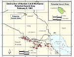
Figure 13. Downwind hazard from Al Muthanna Bunker 2
| First Page | Prev Page | Next Page |