|
Meteorological Model |
|
Dispersion Model |
|
COAMPS |
HPAC/SCIPUFF |
|
|
MM5 |
HPAC/SCIPUFF |
|
|
OMEGA |
HPAC/SCIPUFF |
|
|
COAMPS |
VLSTRACK |
Due to lack of on-site measurements of chemical warfare agent concentrations and meteorological conditions, the identification of hazard areas resulting from the demolition in the Khamisiyah Pit relied almost exclusively on computer modeling. The modeling has been a repeated process due to progressive updates in the source term estimation, personnel and location data, state-of-the-art dispersion and meteorological modeling techniques and assumptions, availability of declassified meteorological observations, and interpretation of toxic thresholds. This section concisely summarizes the modeling activities for a general audience, whereas Appendix A describes the technical details of our approaches to developing hazard areas for readers who have some background in meteorological and dispersion modeling.
Although we describe the Khamisiyah Pit demolition, the general meteorological and dispersion modeling methodologies also apply to other incidents investigated by DHS.
Atmospheric dispersion models predict concentrations of chemical warfare agents after they are released into the atmosphere. These models simulate the mixing and dilution of agents due to turbulence in the atmospheric boundary layer. The concentrations these computer models predict form the basis for developing potential hazard areas. In general, dispersion models require four types of input data:
Source Term. The source term defines the release’s type and magnitude. For example, a release can be instantaneous or continuous, in purely a vapor or liquid droplet form, ground-based or elevated, and small or large. The source term can be directly measured, estimated by field and laboratory experiments, or estimated by computer models.
Surface Characteristics. Surface characteristics describe conditions of terrain, including vegetation, roughness, elevation, temperature of water bodies, etc. Many types of surface characteristic databases, often derived from satellite observations with additional derivations, are available from sources such as the US Geological Survey.
Meteorological Conditions. Meteorological conditions, including wind direction and speed, temperature, moisture, and atmospheric stability can be directly measured or estimated by computer models. Meteorological models are either diagnostic or prognostic, depending on whether they can forecast. In general, diagnostic models spatially interpret weather data based on available observations. These models, while less computationally intensive, cannot forecast, but are ideal if provided sufficient weather observations over the area of interest. Prognostic models, which require many more computational resources than do diagnostic models, are based on fundamental laws of conservation of mass, momentum, and energy, and thus can predict the evolution of atmospheric conditions. The daily weather forecast that is seen on television primarily results from these prognostic models. We used prognostic models to reconstruct prevailing meteorological conditions during the Khamisiyah Pit demolition. In addition, if the scale of the modeling domain ranges between a few hundred to a few thousand kilometers, they are often called mesoscale models. The basic data requirements for mesoscale prognostic models include weather observations at randomly-spaced stations and large-scale (global) model results at regularly-spaced grids to provide the initial and boundary conditions. Prognostic models can run in a pure forecast mode or a four-dimensional data assimilation (FDDA) mode. In pure forecast mode, the model numerically integrates from an initial time (t0) only with data available at t0; the models do not use data available after t0. In FDDA mode, the model incorporates data available after t0 during the course of integration. Operationally, the daily weather forecast is based on mesoscale models run in a pure forecast mode because the data for tomorrow are not yet available. However, if prognostic models were applied to a historical period (i.e., the Khamisiyah modeling), then the data for the whole period would be available and the FDDA mode possible.
Toxic Thresholds. Dispersion models require toxic threshold values to define or delineate potential hazard areas.
In spring 1996, the Presidential Advisory Committee on Gulf War Veterans’ Illnesses (PAC) and National Security Council (NSC) directed the CIA to model the potential chemical fallout from the March 1991 demolition operations at the Khamisiyah Ammunition Supply Point (ASP) to better understand the possible chemical warfare agent release and its dispersion after demolition. CIA accomplished this initial modeling, using primarily two models:
CIA briefed the results to the PAC on July 9, 1996, and published their report on the March 4, 1991, Khamisiyah Bunker 73 (but not the Pit) demolition on August 2, 1996 (CIA, 1996), concluding that the chemical warfare agent likely moved to the east and northeast away from US forces. Additionally, the CIA informed the PAC that uncertainties in the parameters for the modeling prevented definite conclusions about the Khamisiyah Pit explosion on March 10, 1991. Some uncertainties included the number of rockets in storage and damaged, the purity of the agent, the primary release mechanism, and prevailing meteorological conditions. However, initial model results did imply that the hazard areas resulting from the March 10, 1991, demolition in the Khamisiyah Pit would be to the south toward US forces.
On November 2, 1996, Deputy Secretary of Defense John White and Director of Central Intelligence John Deutch asked the Institute for Defense Analyses (IDA) to convene an independent panel of experts in meteorology, physics, chemistry, and related disciplines to "review existing modeling activities, advise on the capabilities of these activities to model effectively the events in question, and to suggest any other modeling efforts that the DoD or other interested parties should undertake." The panel met in November 1996 to review the information available about the Pit demolition, the analyses CIA performed, and DoD’s existing modeling capabilities. A second meeting occurred in February 1997, to review additional analyses requested by the panel at the first meeting.
The IDA panel, concerned about the difficulties in addressing the source of the release and scarcity of surface and high-altitude meteorological data in the Persian Gulf region, recommended several steps that have guided DoD’s and the CIA’s subsequent modeling efforts (IDA, 1997):
In addition, the IDA panel consulted the Director of the National Oceanic and Atmospheric Administration (NOAA) Air Resources Laboratory, who concurred with the ensemble approach of hazard prediction the IDA panel recommended.
After the IDA panel review, the DoD and CIA began full-scale modeling efforts of the Khamisiyah Pit demolition. While they followed specific IDA panel recommendations in most regards, the DoD and CIA further expanded the study to attempt to reduce the uncertainty in the source term. As an alternative to producing a large matrix of possible modeling outcomes resulting from extensive parametric studies, the DoD and CIA embarked on an aggressive effort to establish the modeling parameters for the release from the detonations. This effort consisted of in-depth interviews with five soldiers who prepared the 122mm rocket stacks in the pit, extensive examination of the UNSCOM’s records and interviews with its personnel, and field and laboratory testing. Table 2 shows the descriptions CIA provided for the 1997 release.
Table 2. Source parameters used in the 1997 Khamisiyah Pit modeling
|
Parameter |
Best Estimate |
Description of Uncertainty |
| Number of events | One event on March 10, 1991 | Very unlikely other demolitions of chemical agent munitions took place. |
| Time of event | 1615 local time (1315 Universal Time Coordinated (UTC)) | Could be 5 minutes later, based on reported delay in detonation of the Pit. |
| Location | 30�
44’32"N 46� 25’52"E |
Based on UNSCOM GPS reading. |
| Weight of liquid fill | 6.3 kg per rocket | Based on examining SAKR-18 plastic inserts; minor uncertainty (� 0.l kg). |
| Combined agents’ purity | 50% | Based on documentation UNSCOM obtained; purity of individual batches ranged between 40 and 60 %. |
| Ratio of sarin to cyclosarin | 3:1 | Based on data from one rocket in the pit. Could be as low as 1:1 based on Iraq’s past practices, or as high as 4:1 based on sample uncertainties. |
| Number of rockets in Pit | 1250 | Could be as many as 1400 or as few as 1100. |
| Number of rockets damaged in demolition | 500 | Based on UNSCOM and intelligence, could be as many as 650 or as few as 170, based on number of rockets minus rockets UNSCOM found that were undamaged. |
DoD and CIA jointly designed a field test to further characterize the source data for the Khamisiyah Pit detonation. In May 1997, the US Army Dugway Proving Ground conducted the test comprised of seven field trials using a total of 33 122mm chemical rockets. Nudell et al., (2000) describe the tests in detail, which involved a series of detonations of individual rockets and several trials of rocket stacks. Except for the limited number of rockets available and using a simulant instead of chemical warfare agent, the incident was recreated based on interviews with the soldiers who placed the charges at Khamisiyah.
Using the results from these 122mm rocket tests, additional computer modeling assessed the rocket damage resulting from various placements of charges and orientations of rockets. This numerical modeling provided a basis for estimating the total number of rockets destroyed and the distribution of the agent instantaneously released to the atmosphere in vapor form and in liquid droplet form, and spilled on wood and soil and subsequently evaporated or remaining. The results showed 2% of the agent instantaneously released into the atmosphere and 16% spilled on wood and soil and then slowly evaporated over time. To estimate the agent’s evaporation rate from wood and soil, Dugway Proving Ground and the Edgewood Chemical Biological Center performed additional laboratory tests with chemical warfare agent; soil, including some from Iraq, assessed as similar to the pit sand; and pine, a wood commonly used for 122mm rocket crates.
In fulfilling the IDA panel’s recommendations to consider employing an ensemble of models and the union of the hazard areas predicted by all models, DoD adopted the Hazard Prediction and Assessment Capability/Second Order Closure, Integrated Puff (HPAC/SCIPUFF) and Chemical/Biological Agent Vapor, Liquid, and Solid Tracking (VLSTRACK) dispersion models, as recommended in a 1996 memorandum from the Deputy Under Secretary of the Army (Operations Research). DoD also adopted the following three mesoscale meteorological (prognostic) models to provide the necessary high-resolution meteorological information for the two dispersion models:
The CIA’s Khamisiyah modeling had used COAMPS and OMEGA. MM5 is a mesoscale prognostic model widely used in the academic community. In 1997, DoD adopted the ensemble of four meteorological and dispersion model linkages (or combinations) shown in Table 3:
Table 3. Meteorological and dispersion model linkages
|
Meteorological Model |
|
Dispersion Model |
|
COAMPS |
HPAC/SCIPUFF |
|
|
MM5 |
HPAC/SCIPUFF |
|
|
OMEGA |
HPAC/SCIPUFF |
|
|
COAMPS |
VLSTRACK |
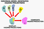
With two dispersion and three meteorological models, the number of possible model linkages is six. However, DoD used only the above four because a tight deadline did not allow enough time to develop the data conversion programs for the MM5/VLSTRACK and the OMEGA/VLSTRACK combinations. Following the IDA panel’s recommendation, DoD and CIA used this ensemble to identify the union (Figure 4) of the individual hazard areas these four model combinations predicted as the potential hazard areas.
Figure 4. Example of process for creating composite area
Both HPAC/SCIPUFF and VLSTRACK are PC-based[6] , Gaussian puff dispersion models that accept spatially-varying meteorological fields and calculate the mean velocity profile and planetary boundary layer turbulence based on similarity theories. HPAC/SCIPUFF bases its dispersion parameterization on second-order turbulence closure theory (Sykes et al., 1998). As a result, the model can predict not only the mean concentration, but also the concentration variance or fluctuation, which means HPAC/SCIPUFF can produce results based on probability. VLSTRACK, on the other hand, follows the traditional dispersion modeling approach and predicts only the mean concentration (Bauer and Gibbs, 1998).
OMEGA, COAMPS, and MM5 are all three-dimensional mesoscale models that solve the fundamental primitive equations governing atmospheric flows. They are highly computationally intensive and usually run on supercomputers or powerful workstations. They use different parameterization schemes to simulate physical processes (e.g., surface heat and water vapor fluxes, moist convection, and short- and long-wave radiation). COAMPS and MM5 are more similar because both use a structured grid that can be multiply-nested to focus on smaller areas of interest. OMEGA uses an unstructured grid that can dynamically adapt to the surface layer topography. COAMPS and OMEGA apply the Level 2.5 planetary boundary layer scheme developed by Mellor and Yamada (1974). MM5 uses non-local planetary boundary layer schemes that accommodate the influence of large, energetic eddies.
All mesoscale meteorological models rely on large-scale (i.e., global) gridded fields to provide the initial and boundary conditions. Global meteorological models generate the global fields for the various mesoscale models as follows:
Besides the gridded global field inputs, mesoscale models also require meteorological observations such as measurements from surface stations, fixed and drifting buoys, civilian ship reports, pilot balloon and rawinsonde observations, aircraft reports, temperature soundings from satellites, and cloud-track winds from geo-stationary satellites. Declassified observations were included when possible. All available observations were collected in areas surrounding Iraq, since, other than a few isolated declassified observations, the whole area of Iraq was devoid of any regularly-reported weather observations. This lack of weather observations is why meteorological modeling played a critical role in reconstructing the weather conditions over Iraq.
As stated earlier, mesoscale models can use observations in two ways—in pure forecast or FDDA mode. In pure forecast mode, a mesoscale model starting integration from t0 (e.g., 0000 UTC March 10, 1991) uses only those observations surrounding t0 (usually � six hours) without incorporating observations corresponding to later times. In FDDA mode, as the model integrates forward in time (e.g., t0+24 hours) it uses observations for later times to nudge solutions towards the observed atmospheric state. In analyzing a historical period, the FDDA mode is preferable because the incorporation of observational data throughout the period makes its solutions more accurate. FDDA performs mainly in two ways: intermittent FDDA assimilates data at distinct time intervals (e.g., every 12 hours) by objective analysis; continuous FDDA assimilates observations continuously by modifying the basic governing equations with a forcing term from the error. COAMPS and MM5 used intermittent FDDA throughout all the modeling; OMEGA did not have FDDA in earlier modeling, but used intermittent FDDA for the 2000 modeling.
The gridded outputs that mesoscale weather models generate provide dispersion models their necessary meteorological inputs. Due to differing meteorological versus dispersion model data resolutions and formats, it is necessary to convert the meteorological model outputs before the dispersion models can accept them. The approach in HPAC/SCIPUFF has been to reconstruct artificial soundings at selected locations (~ 400 in total) based on the three-dimensional gridded meteorological model outputs. The dispersion models then treated these artificial soundings as observations. HPAC/SCIPUFF has two integrated diagnostic meteorological models. When HPAC/SCIPUFF read in these artificial soundings resulting from meteorological model outputs, it further adjusted the wind field with its own diagnostic models to ensure air mass consistency. VLSTRACK, on the other hand, ingested directly the full meteorological fields.
We used the results from the following to produce source characteristics for HPAC/SCIPUFF and VLSTRACK:
Even though both HPAC/SCIPUFF and VLSTRACK have built-in generic algorithms to calculate various munitions’ evaporation rates, we bypassed these algorithms to use the explicit specification of sarin’s and cyclosarin’s evaporation rates over a four-day period from the above tests. These time-varying evaporation rates, in conjunction with the number of rockets damaged, account for the percentages of agent released in various pathways (including instant aerosolization, spilled onto wood and soil, penetrated into wood, etc.), and the rates at which the agent ultimately entered the atmosphere. The agent spill fraction is not necessarily the same as the agent evaporation fraction. The former defines how much agent rockets release, whereas the latter defines how much agent actually enters the atmosphere and produces airborne hazard. To estimate vapor hazards, dispersion models mainly require the evaporation fraction rate rather than the spill fraction. For example, a large amount of toxic substance might spill onto the ground, but the substance might evaporate slowly due to low volatility, so the airborne hazard due to the spill in fact is quite limited.
It is necessary to define toxic thresholds in order to quantify potential hazard areas resulting from the agent release. The potential hazard areas are essentially areas enclosed by equal-concentration contours for different thresholds. Of the three toxic thresholds that DoD used, the first two are expressed as dosage (i.e., concentration integrated with time) and the third is expressed as concentration:
More detailed discussions of the above toxic thresholds are provided in Section IV.D.5.
Once the modeling teams delineated the hazard areas, USACHPPM could determine the possibly affected units. USACHPPM obtained unit locations based on unit identification code from the US Armed Services Center for Unit Records Research (USASCURR) database, which contains daily unit geographic locations within the Operation Desert Storm theater of operations. USACHPPM then used geographic information system techniques to place units on a daily basis on an operational base map and overlaid the modeled daily potential hazard areas on this. The Defense Manpower Data Center and the Office of DHS then took the unit identification codes for those units within the potential hazard area boundaries and identified the individuals in those units. The CIA and DoD published their preliminary results in a September 4, 1997, report (CIA and DoD, 1997) estimating the total population within the potential hazard area, defined by the GPL (i.e., low-level exposure threshold) over the four days of March 10-13, 1991, as 98,910. There were no forces identified within the FNE exposure area.
Due to the deadline, the results contained some limitations and assumptions, including:
In November 1997, DoD asked a peer review panel of experienced senior atmospheric scientists to review the overall technical approach to the modeling of the Khamisiyah Pit demolition. The panel consisted of Dr. Richard Anthes of the University Corporation for Atmospheric Research, Dr. Steven Hanna of George Mason University, and Messrs. Bruce Hicks and William Pendergrass of the National Oceanic and Atmospheric Administration. Besides endorsing using a union of results from several independent meteorological and dispersion models to identify possibly exposed personnel, the panel also commented (Anthes et al., 1997):
D. Analysis Changes for the 2000 Modeling
In response to these comments from the peer review panel and with new intelligence and scientific information that had become available, DoD continued its efforts to improve the analyses for the Khamisiyah modeling process. The refinements were mainly in six areas: (1) meteorological modeling, (2) estimate of the total number of rockets destroyed, (3) consideration of agent removal mechanisms, (4) unit location and personnel data, (5) sarin and cyclosarin exposure thresholds, and (6) the combined toxicity of sarin and cyclosarin.
1. Meteorological Modeling. The meteorological modeling changed from 1997 in two aspects: (1) changes in modeling and input data options (for COAMPS and MM5), and (2) changes in model codes (for OMEGA). For example, NRL made several COAMPS sensitivity runs. The 2000 COAMPS runs incorporated all available observations, rather than denying some observations, as occurred in 1997. The resolution of the land-use database in MM5 improved to 1 kilometer, and NCAR included many declassified observations. DTRA improved some OMEGA numerical and turbulence-closure schemes by changing the code; moreover, their 2000 OMEGA runs operated in 12-hour intermittent FDDA mode, instead of the pure forecast mode previously used.
In addition to the demolition in the Khamisiyah Pit, DoD also was investigating several other possible chemical warfare agent release incidents that required modeling meteorological conditions. Therefore, DoD decided to undertake a time-consuming task: have the three meteorological modeling proponents (NCAR for the MM5 model, DTRA for OMEGA, and NRL for COAMPS) reanalyze the meteorology during the two-month period from January 16, 1991, through March 15, 1991, of the Persian Gulf War. The reanalysis produced a valuable, consistent database, more than 400 gigabytes in size, of predicted meteorological fields over the region. Whenever the need arises to investigate a particular incident, it is only a matter of retrieving the meteorological data for the corresponding geographical area and time period and then conducting dispersion modeling.
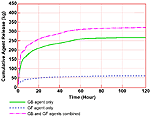
2. Number of Rockets Destroyed. After releasing the 1997 results, the intelligence community continued to refine its estimate of the Khamisiyah source characteristics. According to an unclassified October 14, 1999, CIA memorandum, the number of 122mm rockets damaged during the Khamisiyah Pit demolition was 225, instead of the previously estimated 500. Thus, CIA reduced the overall source mass emissions by 55 percent. Other assumptions (e.g., the initial mixing ratio of sarin and cyclosarin and their evaporation rates’ time-dependence) remained unchanged. Figure 5 shows the cumulative sarin and cyclosarin release based on the volume within the number of damaged rockets used in the 2000 modeling.
Figure
5. Cumulative agent release for the Khamisiyah Pit release
expressed as a function of time
3. Agent Removal Mechanisms. Two phenomena—dry gaseous deposition and agent decay—in the atmospheric boundary layer affect the dispersion models’ estimates of the concentration of the released chemical warfare agent based on time and distance. The 2000 modeling used the dry gaseous deposition value of 0.3 centimeters per second (cm/s) for sarin and cyclosarin’s physical properties and NSWC changed the VLSTRACK code. Moreover, the 2000 results also incorporate agent decay due to hydroxyl reactions during daytime hours. Recent research shows nitrate radicals are the primary nighttime decay mechanism. However, since nitrate data was unavailable, the modeling teams ignored nighttime decay so the predicted agent concentrations will be higher, i.e., the predicted hazard areas will be larger.
4. Unit Location and Personnel Identification. The USASCURR maintained two data sets essential in determining veterans possibly exposed. The first was a registry of Gulf War veterans with their Gulf War unit identification. The second was a registry of daily unit locations during the war. By associating information from these two data sets, DoD developed a list of possibly exposed veterans during the March 10 through 13, 1991, timeframe. Since 1997, continuing DoD efforts have improved both the quantity and quality of the unit location and personnel data. For example, the original unit location and personnel data depended primarily on records, which were later found to be incomplete and in some cases erroneous. As a result, from 1997 to 1998 we held a series of meetings with troop units’ operations officers to refine the data. Additionally, the 1997 data contained no information about Air Force personnel—a shortcoming the 2000 unit identification efforts addressed. These efforts led to more comprehensive data with higher quality and accuracy.
5. Exposure Thresholds. We use the FNE and GPL to define potential hazard areas and the M8A1 alarm threshold for comparison with reported detections, if any. The GPL indicates low-level exposure, whereas the FNE and M8A1 indicate short-term exposure and the area where chemical warfare agent detection equipment would alarm. The M8A1 is expressed as concentration, while the FNE and GPL-based criteria are expressed as dosage (concentrations integrated with time).
In the 2000 modeling, the FNE dosage of sarin remains unchanged at 1.0 mg-min/m3. The literature suggests associating averaging periods ranging from 10 minutes to 4 hours with this dosage (e.g., both an average concentration of 0.1 mg/m3 over 10 minutes or 0.004167 mg/m3 over 4 hours will yield the same dosage of 1 mg-min/m3). DoD chose an averaging time of 10 minutes in the 2000 modeling because it is most consistent with laboratory data with minimal extrapolation. For the FNE, cyclosarin was assumed twice as toxic as sarin (Mioduszewski, et al., 1998). Thus, cyclosarin’s FNE dosage is 0.5 mg-min/m3, i.e., half that of sarin. Table 4 summarizes the sarin and cyclosarin FNE exposure thresholds (dosage, applied time).
|
Agent |
Dosage |
Time |
|
sarin
|
1.0 mg-min/m3 |
10 minutes |
|
cyclosarin |
0.5 mg-min/m3 |
10 minutes |
After a careful review (see Section III.D.3), the USACHPPM suggested a short-term GPL is more relevant for the Khamisiyah modeling, and the appropriate short-term GPL concentration for sarin should be 0.00003 mg/m3. As a result, the 2000 modeling uses a sarin GPL dosage of: 0.00003 mg/m3 times 1440 minutes (24 hours) = 0.0432 mg-min/m3. For the GPL, cyclosarin was assumed to be three times more toxic than sarin (Mioduszewski, et al., 1998), resulting in a GPL dosage of 0.0144 mg-min/m3 for cyclosarin. Table 5 summarizes the GPL exposure threshold calculations:
Table 5: Sarin and cyclosarin GPL exposure threshold calculations
|
Agent |
Concentration |
Time |
Dosage |
|
sarin |
0.00003 mg/m3 |
24 hours |
0.0432 mg-min/m3 |
|
cyclosarin |
0.00001 mg/m3 |
24 hours |
0.0144 mg-min/m3 |
| First Page | Prev Page
| Next Page |