2. Modeling Chemical Warfare Agent
In the spring of 1997, the Presidential Advisory Committee for Gulf War Illnesses (PAC) recommended that definitive studies identifying the possible hazard due to the release of agent from the Khamisiyah Pit be completed as soon as possible after the completion of the Dugway tests. In early summer 1997, various organizations completed the preliminary analyses for the Dugway rocket-detonation test results, agent-evaporation test results, and the supporting source-distribution modeling. As described above, CIA combined these analyses to provide an empirical, time-dependent evaporation curve for the nerve agent components (GB and GF), thus quantitatively defining the source term. As previously described, NRL (running COAMPS), DTRA (running OMEGA), and NCAR (running MM5) produced meteorological runs to define the mesoscale meteorological fields. The Dugway source data and meteorological outputs were then used as inputs to dispersion models, VLSTRACK and HPAC/SCIPUFF. Due to the haste in performing the final dispersion calculations, the July 1997 VLSTRACK runs did not use the Dugway evaporation curve, but instead applied the model’s internal evaporation algorithms. CIA and DoD released the modeling results to the public in July 1997 (CIA and DoD, 1997).
a. Meteorological Modeling. This section describes the initial set of meteorological modeling experiments carried out with COAMPS, OMEGA, and MM5. These models estimated the mesoscale meteorological conditions near Khamisiyah within several days of the detonation at the Pit. DoD used the results of the meteorological modeling to produce the hazard areas published in July 1997 (CIA and DoD, 1997).
1) Large-Scale Analyses. To provide the global environment within which the mesoscale models adjust the large-scale flow to local characteristics, rawinsonde and surface data were mapped to the mesoscale model grids using objective-analysis procedures with first-guess fields based on the GDAS archived data for OMEGA, the NCEP reanalysis and operational ECMWF global analysis for MM5, and the NOGAPS global reanalysis for COAMPS. Linear temporal interpolations of 6-hourly global fields defined the lateral boundary conditions for COAMPS and MM5’s outer grids and the OMEGA grid. The GDAS, NCEP, and ECMWF analysis fields, used to both initialize and provide the lateral boundary conditions for MM5 and OMEGA, are written to a 2.5� by 2.5� global grid. The NOGAPS reanalysis has a resolution of 1.0� by 1.0� .
The following paragraphs describe the prevailing large-scale conditions as predicted by one of the global models, NOGAPS (Westphal et al., 1999). The meterological predictions of the other large-scale global models are qualitatively similar.
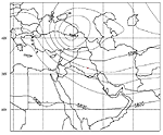
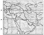
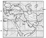
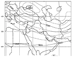
Just before the Pit demolition on March 10, 1991, the synoptic-scale weather over southern Iraq was undergoing a transition. On March 8-9, 1991, an upper-level (500mb) low whose center was moving southeastward from the Black Sea (Figure A-24) to extreme southeastern Turkey (Figure A-25) dominated the synoptic conditions.
Figure
A-24. NOGAPS upper level (500mb) contours for 0000 UTC
on 03/08/91
Figure
A-25. NOGAPS upper level (500mb) contours for 0000 UTC
on 03/09/91
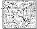
The NOGAPS 1000mb analysis fields indicate the corresponding surface low migrated eastward from Turkey (Figure A-26) to northern Iraq (Figure A-27), with a confluence of winds tracing a ray southward from the trough and passing through southern Iraq, producing winds fluctuating from northeasterly to southeasterly to northwesterly over the period from 0000 UTC March 8 to 0000 UTC March 9, 1991. (Note: The sea level charts reflected in Figures 26, 27, 29, 31, 33, and 35 also show surface winds.)
Figure
A-26. NOGAPS sea level contours for 0000 UTC
on 03/08/91
Figure A-27. NOGAPS sea level contous for 0000 UTC on 03/09/91
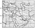
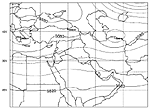
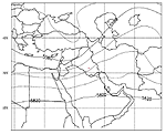
Starting from 1200 UTC on March 10, 1991, synoptic conditions increasingly fell under the influence of a low-pressure system approaching from the west (moving eastward across the Mediterranean). The previously dominant 500mb low moved eastward across northern Iran to the Caspian Sea (Figure A-28).
Figure
A-28. NOGAPS upper level (500mb) contours for 1200 UTC
on 03/10/91
The upper-level flow over Khamisiyah turned westerly as this feature departed. With the surface low accelerating eastward across Iran (Figure A-29), a region of high pressure rebuilt over Iraq with northerly to northwesterly winds over southern Iraq and the northern Arabian Gulf, defining the critical initial trajectory of the released agent. Only minor changes in the upper-level flow occurred over the Khamisiyah region during the next 24 hours.
Figure A-29. NOGAPS sea level contours for 1200 UTC on 03/10/91
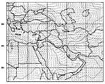
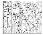
At 1200 UTC on March 11, 1991, a flat ridge between the lows departing and approaching the region developed over Iraq and northern Saudi Arabia (Figure A-30).
Figure
A-30. NOGAPS upper level (500mb) contours for 1200 UTC
on 03/11/91
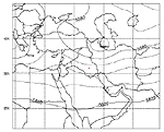
At the surface, high pressure continued to build.over northern Iraq and Iran (Figure A-31). The surface winds were generally northeasterly over most of southern Iraq. As the large, upper-level low arrived over the eastern Mediterranean (Figure A-32), the ridge ahead of this trough continued to amplify as it moved eastward over the Khamisiyah region
Figure A-31. NOGAPS sea level contours for 1200 UTC on 03/11/91
Figure
A-32. NOGAPS upper level (500mb) contours for 1200 UTC
on 03/12/91
At 1200 UTC on March 12, 1991, a shallow surface low moved into central Saudi Arabia and a shallow surface high formed in the eastern part of the country near the Arabian Gulf (Figure A-33). With the low over western Iraq and central Saudi Arabia, the strong high pressure over Iran, and the shallow area of high pressure in the Arabian Gulf; the 1000mb winds shifted to southeasterly over southern Iraq and northeast Saudi Arabia.
Figure A-33. NOGAPS sea level contours for 1200 UTC on 03/12/91
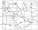
By 1200 UTC on March 13, 1991, the 500mb low moving eastward over the Mediterranean arrived over Syria and western Iraq (Figure A-34). The ridge preceding this trough continued to amplify as it moved over Iran. At the surface, the low moved to northeastern Saudi Arabia and southern Iraq (Figure A-35), driving the 1000mb winds over most of the Arabian Gulf southeasterly ahead of it. Over the rest of Iraq behind the low, the winds shifted northwesterly. By 0000 UTC on March 14, 1991, all southern Iraq experienced northwesterly winds as the surface low moved into Iran.
FigureA-34.
NOGAPS upper level (500mb) contours for 1200 UTC
on 03/13/91
Figure A-35. NOGAPS sea level contours for 1200 UTC on 03/13/91
2) Mesoscale Analyses. The COAMPS results presented in this section are based on the 1997 modeling. For the Khamisiyah studies, the most pertinent difference between the 2000 and the 1997 COAMPS modeling is the land-use database resolution. The 2000 land-use database has a resolution of 1 km and the coastline database has a resolution of 500 m. The 1997 modeling used 1� land-use data. DoD used OMEGA 2.0 baseline Khamisiyah simulations for dispersion studies completed through September 1997. These meteorological fields reflect uniform surface properties. A diagnostic review of OMEGA 2.0 led to enhancements to eliminate spurious, numerically-generated gravity waves and excessive surface heating. OMEGA Version 3.7, used in the 2000 modeling, reflects these enhancements and the implementation of a suite of high-resolution surface characteristic databases.
The COAMPS reanalysis starts from the reanalyzed NOGAPS fields at 1200 UTC March 8, 1991, two days, or four data assimilation cycles, before the detonation and continues through 1200 UTC on March 15, 1991. MM5 was initialized from the NCEP and ECMWF global analysis fields at 0000 UTC March 8, 1991, and applied the nudging technique continuously for 72 hours after the release. OMEGA 2.0 was initialized with the GDAS analysis at 1200 UTC on March 10, 1991, and integrated for 72 hours without further data assimilation.
3) Sensitivity Studies. The Khamisiyah demolition occurred in a data-sparse region for mesoscale analysis. The boundary conditions supplied by a global analysis likely will dominate solutions for a limited-area model (Anthes and Warner, 1978). Figure A-19 showed that several sounding sites surrounding the data-void region of Iraq were used within the limited area being modeled. To explore the variations resulting from uncertainties in observations, as well as in the reanalyses, and to assess the stability of the global and mesoscale baseline analyses described above, several sensitivity analyses were carried out.
a) COAMPS
Following the IDA panel’s recommendations, NRL conducted several analyses characterized by perturbed weather inputs. These alternative analyses consisted of: (1) a COAMPS analysis where all observations within the COAMPS 15-km grid domain (described in Section III.C.1.d) were denied in the data assimilation process; (2) NOGAPS and COAMPS analyses denying all observations within the COAMPS 45-km domain; and (3) NOGAPS and COAMPS analyses introducing random, bounded errors into the global observation database according to the type and altitude of observations. Table A-9 lists the three alternate reanalyses. The COAMPS reanalysis, DD45 (COAMPS 4), is simply a forecast with boundary conditions from the global analysis and did not assimilate observations. The baseline run is called COAMPS 7.
Table A-9. Alternative reanalyses used in the Khamisiyah study
|
Reanalysis |
Name |
Characteristics |
| Data denial on 15-km grid |
COAMPS 3 (DD15) |
Data denied to COAMPS inside 15-km grid |
| Data denial on 45-km grid |
COAMPS 4 (DD45) |
Data denied to COAMPS and NOGAPS inside COAMPS 45-km grid |
| Perturbation of observations |
COAMPS 6 (RPO) |
All global observations randomly perturbed before QC and data assimilation for NOGAPS and COAMPS |
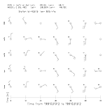
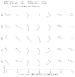
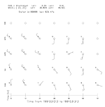
For comparison, Figures A-36 and A-37 show simultaneous displays of wind barbs (meteograms which depict wind direction and speed) for observations and the various COAMPS reanalyses at Hafar-al-Batin (925mb) and Hail (850mb). At Hafar-al-Batin, all analyzed wind speeds are within 2.5 m/s of the observation. Moreover, all four analyses exhibit an observed anticyclonic wind shift from NNW to SSE and then to WSW during the 72 hours after the release. At Hail, the wind shift is similar; however, the southerly wind component began 12 hours earlier than at Hafar-al-Batin. All four analyses once again reproduce these observed wind conditions. Finally, Figure A-38 shows meteograms of the four reanalyses at Khamisiyah (925mb), where observations were unavailable. Given the likely slow evaporative release at the Khamisiyah Pit, local winds are crucial over several days to transport the chemical warfare agent downwind. Excepting very light wind conditions, all wind directions are within 30� of each other. These comparisons suggest that, while denial of, and random errors in, observations in the reanalysis fields lead to quantitative differences, the mesoscale models generally accurately portrayed atmospheric flow fields.
Figure A-36. Meteograms (observations and predictions) for Hafar-al-Batin
Figure A-37. Meteograms (observations and predictions) for Hail
Figure A-38. Meteograms (predictions only) for Khamisiyah
b) OMEGA
As described above, DTRA considered three OMEGA 2.0 simulations that represented increasingly enhanced obserations and horizontal resolution, where Run k10y is the baseline run.
Additionally, the OMEGA 2.0 k10y simulation was initialized using two global gridded analyses: the 1991 GDAS and the 1997 NOGAPS reanalysis. The diagnostics of the OMEGA 2.0 results indicated a consistent temperature bias and a tendency towards spurious vertical oscillations caused by vertical acoustic waves excited within the model that the implicit solver did not effectively filter. As a result, the model was updated to OMEGA Version 3.7 for the 2000 modeling with a new sponge filter to damp vertically propagating acoustic waves. Other enhancements in OMEGA 3.7 include minor changes to the top and lateral boundary conditions, a new horizontal diffusion algorithm, and a new vertical advection solver. In addition, OMEGA 3.7 has adopted an enhanced PBL model, which introduces improved surface-flux parameterizations and extensive use of high-resolution surface properties.
c) MM5
To examine MM5’s sensitivity to global analysis fields and boundary layer parameterization schemes, NCAR performed three three-day experiments, summarized in Table A-10. Experiment 1 employed the MRF PBL parameterization and the ECMWF global analysis. Experiment 2 used the same model physics, but used the NCEP global analysis instead of the ECMWF. Experiment 3 was the same as Experiment 1 except that the Blackadar PBL parameterization scheme was used.
Table A-10. Alternative reanalyses used in the spring ‘97 MM5 sensitivity study
|
Experiment Number |
Large Scale Analysis |
Boundary-layer Parameterization |
|
1 |
TOGA/ECMWF |
MRF |
|
2 |
NCEP |
MRF |
|
3 |
TOGA/ECMWF |
Blackadar |