APPENDIX A — Hazard Area Assessment (Modeling And Simulation)
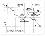
In the spring of 1996, the Presidential Advisory Committee on Gulf War Veterans’ Illnesses (PAC) and the National Security Council (NSC) directed the Central Intelligence Agency (CIA) to model the possible chemical fallout from the US forces’ March 1991 demolition at the Khamisiyah Ammunition Supply Point (ASP) located in southern Iraq (Figure A-1) to better understand the possible chemical warfare agent release and dispersion during and after the demolition. CIA performed this modeling using the Army's Chemical and Biological Defense Command's Non-Uniform Simple Surface Evaporation 4 (NUSSE4) transport and dispersion model and the Defense Threat Reduction Agency (DTRA)’s Operational Multi-scale Environmental Model with Grid Adaptivity (OMEGA) weather model. The Department of Defense (DoD) commonly uses NUSSE4 to study the tactical use of chemical weapons, though its dispersion pattern is invalid at distances greater than 25 kilometers from the source. CIA briefed the results to the PAC on July 9, 1996, and published its report (CIA, 1996) on August 2, 1996. Emphasizing the March 4, 1991, bunker 73 explosion, CIA concluded the chemical warfare agent likely moved to the east and northeast—away from US forces. However, the report stated that uncertainties in the modeling process prevented definite conclusions about the March 10, 1991, explosion in an area near the Khamisiyah ASP, commonly called the Pit. These uncertainties included: conflicting reports on the number of rockets, lack of knowledge about the purity of the agent, and uncertainty about the primary release mechanism. The model runs indicated this detonation would produce a possible hazard area that would travel in a southerly direction toward US forces.
Figure A-1. Khamisiyah in Iraq
In November 1996, DoD initiated efforts to develop a comprehensive reconstruction of the events associated with the March 10 demolition. DoD began its meteorological reconstruction using DTRA’s[8] OMEGA model and its embedded atmospheric dispersion model to predict downwind hazards. In addition, to produce additional data, DoD used the Hazard Prediction and Assessment Capability/Second-Order Closure, Integrated Puff (HPAC/SCIPUFF) transport and dispersion model, which accepts the temporal and spatially varying fields the OMEGA model generates. The availability of declassified meteorological observations further aided DoD’s effort. To validate this analysis, DoD engaged the Naval Research Laboratory (NRL) and Naval Surface Warfare Center (NSWC) to independently run the Coupled Ocean-Atmosphere Mesoscale Prediction System (COAMPS) and the Chemical/Biological Agent Vapor, Liquid, and Solid Tracking (VLSTRACK) model to provide complementary results.
Additionally, on November 2, 1996, Deputy Secretary of Defense John White and Director of Central Intelligence Agency John Deutch asked the Institute for Defense Analyses (IDA) to convene an independent panel of experts in meteorology, physics, chemistry, and related disciplines to review existing modeling activities, advise on these activities’ capabilities to effectively model the events in question, and suggest any other modeling efforts DoD or other interested parties should undertake.
The panelists included:
At their first meeting, November 18-20, 1996, the panel reviewed what was then known about the demolition in the Pit, CIA’s analyses using the NUSSE4 and OMEGA models, and existing other modeling capabilities in DoD and the Department of Energy.
After this meeting, the IDA panel suggested various additional organizations perform similar analyses. These new efforts should include (IDA, 1997):
The results of these additional modeling activities, presented at a second IDA meeting on February 13, 1997, differed greatly. In particular, the DTRA (OMEGA/HPAC-SCIPUFF) and LLNL (MATHEW/ADPIC) results showed similar directions for agent transport initially. However, the DTRA results predicted the agent eventually turned westward, while the LLNL results showed the agent would continue southeasterly towards the Persian Gulf. The NRL/NSWC models (COAMPS/VLSTRACK) showed a trajectory toward the southeast that turned westward and then back toward the north as the wind changed. Further investigation suggested that the coarser resolution meteorological fields (2.5x2.5-degree NOAA/National Center for Environmental Prediction reanalysis fields) LLNL used failed to resolve the crucial boundary layer transport process. Hence, the panel viewed the MATHEW/ADPIC results as probably less accurate.
In conclusion, the IDA panel recommended the modelers follow these procedures:
In spring 1997, the Office of the Special Assistant to the Deputy Secretary of Defense for Gulf War Illnesses assumed responsibility for coordinating the efforts of the various agencies involved in modeling the Khamisiyah Pit demolition. Effective April 2001, the office became the Directorate For Deployment Health Support of the Special Assistant to the Under Secretary of Defense (Personnel and Readiness) for Gulf War Illnesses, Medical Readiness, and Military Deployments. (Hereafter, we refer to both as the Directorate For Deployment Health Support (DHS)). Besides the CIA, the modeling participants included the NRL, NSWC, and DTRA. The CIA’s initial findings and the IDA panel’s recommendations guided the modeling effort. In addition to focusing on the atmospheric modelers’ expanded role, DHS, in conjunction with the CIA, aggressively pursued the acquisition of additional data about the detonation in the Pit. Consequently, additional interviews with soldiers who participated in the demolition have reduced uncertainty about the numbers of rockets in the Pit that were destroyed, eliminated uncertainty about the number of detonations, and provided valuable information about the quantity of explosives available and the placement of charges. The United Nations Special Commission on Iraq (UNSCOM) inspection team’s report on the condition of rockets found in the Pit in October 1991 failed to definitively specify the primary mechanism of the agent’s release after detonation. Therefore, DHS, with the CIA’s support, conducted field tests at Dugway Proving Ground to collect specific data characterizing agent release associated with detonating 122mm rockets such as those found in the Pit. An expanded atmospheric modeling effort, together with this additional source data afforded a more reasonable worst-case estimate for the possible extent of chemical warfare agent exposure from the Pit demolition.
The DoD-CIA team publicly released its 1997 modeling analysis of the Khamisiyah Pit release at a press briefing on July 22, 1997, and jointly published the paper "Modeling the Chemical Warfare Agent Release at the Khamisiyah Pit" on September 4, 1997. The Khamisiyah Peer Review Panel (Dr. Richard Anthes, University Corporation for Atmospheric Research; Mr. Bruce Hicks, NOAA; Dr. Steven Hanna, George Mason University; and Mr. William Pendergrass, NOAA) met on November 4-5, 1997, to review the initial results. The panel concurred with the ensemble analysis and reported, "The ensemble approach produces credible predicted concentrations for use in determining the area where service personnel might have been exposed to significant health impacts due to hazardous chemical warfare agent releases." The DoD and CIA team addressed the panel’s concerns by performing enhanced OMEGA and MM5 Khamisiyah runs, developing more consistent dispersion results, and updating Coalition forces’ locations and, subsequently, completed a series of Khamisiyah simulations in 2000. The Khamisiyah Peer Review Group reviewed the simulations in early 2000.
II. RECONSTRUCTION AND REANALYSIS METHODOLOGY
1. The Demolition Event at the Khamisiyah Pit
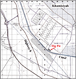
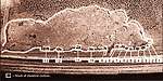
Analysts have called the Khamisiyah Pit a barrow pit; soldiers who have been there have called it variously a wadi, depression, and an embankment. It is located about 2 kilometers south of the closest bunkers at the Khamisiyah ASP (Figure A-2). Starting in mid-February 1991, Iraq began to move stacks of rockets into the Pit along the embankment closest to the road until the Pit contained 13 stacks of rockets just before the ground war started (Figure A-3).
Figure A-2. Location of the Pit
Figure A-3. The 13 stacks of 122mm rockets in the Pit
When the CIA and DoD decided to model the Pit demolition, they quickly realized they had significant uncertainties about how open-pit demolition would have affected rockets with chemical warfare agent-filled warheads. Also uncertain about the number of explosions and weather conditions at the time of the demolitions, the two agencies jointly worked to reduce some of these uncertainties to more accurately identify the extent of the release.
DoD located and, with the CIA, interviewed five soldiers who had key roles in the Pit demolition:
The interviews confirmed the number of stacks of rockets wired for demolition and other information, such as the explosives’ amount and placement on the rockets, that proved invaluable to the field tests discussed below.
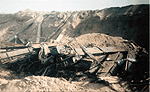
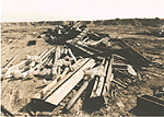
United Nations records also contained valuable information about conditions in the Pit on March 10, 1991. In October 1991, UNSCOM sent a team to inspect Iraq’s chemical weapons storage sites. At Khamisiyah, the team saw a pit area containing 297 122mm rockets, some damaged but most intact, in three to four "heaps." Chemical agent monitors at the site and the rockets’ construction indicated they were chemical warfare munitions and contained nerve agent. Further, a liquid sample taken from one rocket and analyzed by four separate laboratories indicated the rocket contained a mixture of sarin (GB) and cyclosarin (GF) nerve agents. Photographs of the Pit (Figure A-4) taken just days after the demolition show the rockets are identical in appearance, design, and packaging to the chemical warfare agent-filled rockets UNSCOM found (Figure A-5).
Figure A-4. Photo of Pit taken by soldier
Figure A-5. Photo of Pit taken by UNSCOM
2. Input Source Parameters
This section describes the source parameters for the Pit release used in the 1997 modeling (Table A-1), how analysts derived each parameter, the parameters’ uncertainties, and the steps taken to reduce them.
Table A-1. Input source parameters used in the 1997 Khamisiyah Pit modeling
|
Parameter |
Best Estimate |
Description of Uncertainty |
| Number of events | One event on March 10, 1991 | Very unlikely other demolitions of chemical agent munitions took place. |
| Time of event | 1615 Local (1315) Universal Time (Coordinated) (UTC) | Could be 5 minutes later, based on reported delay in demolition of the Pit. |
| Location | 30�
44’32"N 46� 25’52"E |
Based on UNSCOM Global Positioning System (GPS) reading. |
| Weight of liquid fill | 6.3 kg per rocket | Based on SAKR-18 plastic inserts. Small uncertainty (+0.lkg). |
| Combined GB and GF purity | 50% | Based on documentation UNSCOM obtained. Purity of individual batches ranged between 40 and 60%. |
| Ratio of GB:GF | 3:1 | Based on data from one rocket in the Pit. Could be as low as 1:1 based on Iraq’s past practices, or as high as 4:1 based on sample uncertainties. |
| Number of rockets in Pit | 1250 | Could be as high as 1400 or as low as 1100, based on size of crates and stacks of rockets |
| Number of rockets damaged in demolition based on UNSCOM and intelligence | 500 | Could be as high as 650 or as low as 170, based on number of rockets minus rockets found by UNSCOM that were undamaged. |
3. Determining Source Parameters
a. Number of events
The five soldiers involved in either locating or actually destroying the rockets in the Pit indicated the demolition occurred March 10, 1991.
b. Time of event
All five soldiers interviewed indicated the demolitions in the Pit occurred simultaneously with a large demolition on March 10 of around 60 bunkers and 40 warehouses. According to the soldiers interviewed, the event started at 1615 local time (1315 UTC). One soldier remembers the Pit demolition starting a few minutes after the bunker demolition, but for modeling purposes, a 1615 starting time is sufficient.
c. Location
During its May 1996 inspection, UNSCOM took GPS coordinates in the Pit and recorded the location at 30� 44’32"N 46� 25’52"E. In addition, Figure A-3 showed the layout of the stacks.
d. Weight of liquid fill
In preparing for the May 1997 field demolition testing on the rockets, the test team determined a single rocket would hold only 6.3 kilograms (kg) of agent. The estimate accounts for the presence of two plastic canister inserts that reduced the payload volume.
e. Combined GB and GF purity
UNSCOM obtained Iraq’s production records, which indicated the sarin (GB) and cyclosarin (GF) nerve agent produced and transported to Khamisiyah in early January 1991 was about 55% pure. The agent subsequently degraded to 10% purity by the time the four laboratories completed their analyses of samples UNSCOM took from one rocket in October. Assuming the sarin/cyclosarin degraded exponentially, we concluded that the purity was about 50% when the rockets were destroyed two months after production.
f. Ratio of GB to GF
Given the sample purity and indications that the degradation rates for GB and GF are similar, we estimate the ratio when the munitions were destroyed in March 1991 was the same as when the agent was sampled in October 1991—3:1.
g. Estimate of number of rockets present before demolition
In May 1996, Iraq declared to UNSCOM 1,100 rockets were in the Pit at demolition. The DoD-CIA team used personal interviews, estimates of the heights of the stacks of 122mm rockets, and data such as the size of the rocket crates, to develop the estimate of 1,250 rockets.
h. Estimate of number of undamaged rockets
About six months after the demolition, UNSCOM found about 750 rockets still containing chemical warfare agent. UNSCOM assisted Iraq in disposing of these rockets. Therefore, 1997 assessments assumed the demolition destroyed approximately 500 rockets on March 10, 1991.
4. Dugway and Edgewood Testing
In the early stages of the effort to model the Khamisiyah Pit release, analysts were unable to assess whether the demolition released the agent nearly instantaneously or over a period of days. To resolve these uncertainties, CIA and DoD performed field testing with simulants. During April and May 1997, they designed and implemented a series of tests conducted at Dugway Proving Ground, Utah, that significantly enhanced understanding of what happened in the Khamisiyah Pit area on March 10, 1991.
The Dugway testing involved the detonation of a series of individual rockets and stacks of rockets with high-explosive charges placed in a manner described by the soldiers who rigged the stacks in the Khamisiyah Pit. Exact reconstruction was not a realistic goal. Nevertheless, the field testing still provided critical information on the initial conditions required by the dispersion models to predict the consequences. The test team then conducted the demolition characterization tests with these objectives (Nudell et al., 1997):
The small number of rockets available for testing limited the realization of all objectives. Section A.IV.B.1 describes in detail the Dugway tests (Nudell et al., 2000) and the supplementary blast modeling. This information was extrapolated by the modelers to describe the full-pit detonation.
B. Reconstructing Meteorological Data
Analyzing the atmospheric dispersal of toxic agents from the demolitions in the Khamisiyah Pit requires the analysis of the complex, time-dependent mesoscale atmospheric structure at frequent intervals over several days, since agents may evaporate for 60 or more hours after the initial detonation. However, local and regional measurements of atmospheric parameters (e.g., wind speed and direction, vertical temperature structure) in the Khamisiyah area during March 10-13, 1991, are severely limited. Iraq stopped reporting meteorological data to the World Meteorological Organization (WMO) in 1981 during the Iran-Iraq war. Except for scattered surface observations US Air Force (USAF) mobile units took, Iraq weather data essentially was non-existent for this time period. Thus, on March 10 and 11, the closest surface observation stations to Khamisiyah were USAF mobile units in Iraq and Saudi Arabia, 85 km, 130 km and 225 km away, and a WMO upper-air station 270 km to the south at Hafar-al-Batin, Saudi Arabia (Figure A-6).
Figure A-6. Closet USAF weather observation stations to Khamisiyah
Various global data archives contain a coarse-scale representation (e.g., horizontal spatial resolution of 2.5� , or approximately 250 km) of prevailing meteorological conditions from March 10 to 13, 1991. These archived global analysis fields are outputs from global models run operationally during the period of interest and describe the synoptic meteorology for Khamisiyah. Figure A-7 shows a global projection in which each small rectangle bounded by dashed lines covers an area of 30� by 60� . A global analysis with a 2.5� resolution would contain 12 x 24=288 computational grid cells within each rectangle. Operational centers such as the Navy’s Fleet Numerical Meteorology and Oceanography Center (FNMOC), the National Center for Environmental Prediction (NCEP, formerly the National Meteorological Center), and the European Centre for Medium-Range Weather Forecasting (ECMWF) produced global analysis fields during the Gulf War and more recently for reanalysis projects (e.g., Kalnay et al., 1996). Global simulations carried out operationally at civilian national weather prediction centers did not have access to data available over classified networks, including the winds from Saudi Arabian rawinsondes and classified Navy ships, rawinsondes, and surface reports. A 1997 reanalysis of the now-available observation data conducted with the Navy’s global prediction system, the Navy Operational Global Atmospheric Prediction System (NOGAPS), assimilated a comprehensive set of observations, including available declassified observations and any observations that may not have been received by the required time.
Figure
A-7. Projection of globe with 30° x 60° grids
Each 30° x 60° rectangle contains 288 computational cells for a 2.5°
grid resolution.
However, the corresponding horizontal resolution and associated vertical mandatory-pressure level resolution of the global data sets are not sufficient to support a high-resolution calculation of pollutant transport and dispersion in the planetary boundary layer (PBL). The concern with spatial resolution is attributable primarily to the fact that diurnally-varying boundary layer phenomena fundamentally influence the low-level release and atmospheric transport of nerve agents. To satisfactorily account for these phenomena, a model must provide enough levels in the boundary layer to resolve the significant features of wind and temperature distribution, and, from these, to deduce the resulting fluxes of physical quantities and changes of mean variables. In addition, sub-grid scale surface inhomogeneities contained in the 1-to-2.5� global model grid cells result in local flow patterns affecting the agent’s transport and dispersion. Consequently, the role of high-resolution meteorology is pivotal in this analysis. Based on these requirements, in 1999, the DoD and CIA modeling team proceeded to determine the meteorological conditions with high enough resolution in the Khamisiyah area during March 10-13, 1991, by a comprehensive mesoscale reanalysis with the OMEGA, MM5, and COAMPS weather models.
Analogous to an operational forecast application, modelers can use a single archived analysis at a start time as the initial condition to reconstruct mesoscale meteorological conditions for an extended (3- to 5-day) period. This purely forecast method, however, does not use valuable historical data that became available during the course of the simulation, and the model is likely to deviate from the observed state over the forecast period. The optimal mesoscale reconstruction starts with an archived coarse resolution analysis and proceeds one data assimilation cycle at a time. Each data assimilation cycle starts with a short-range forecast by the mesoscale model. The forecast provides first-guess fields that are blended with historical observations through objective analysis. Thus the predicted model fields assimilate relevant observations either periodically or continuously throughout the model integration. This technique is called reanalysis or hindcast.
In implementing the meteorological reconstruction, the DoD team took these specific steps: (1) data acquisition, (2) data assimilation, and (3) mesoscale forecast.